As the week continued on, then number or really good maps increased accordingly. On top of some local weekly trainings the notable areas I went to were: Meech Valley, The Barrens, and March Highlands, each with completely different terrains and styles of orienteering.
In this post I’ll simply analyze / describe the terrains and strategies to use in them when orienteering.
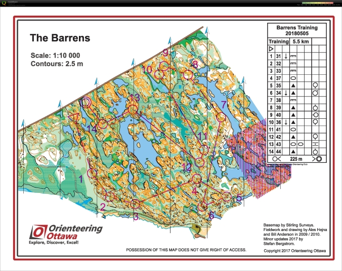
The very nice course that Alex planned out for me 🙂
The Barrens is a completely unique map, that has a certain feel to it that makes it memorable to run on. There are tons of distinct features that make it easy to pick each off while running on a steady compass bearing. With fairly open areas and bare rock mapped as yellow to show the runnability, it becomes easy to move fast and indulge in the navigation.


The mix of swamps and positive contour features remind me of coastal Scandinavian terrain, also imitating the style that it should be approached with.
The only important things to avoid are the lakes or impassible swamps, unless you really want to go for a swim, thus making “straight as the crow flies”, the optimal route for most controls.


It was a nice run, on which I almost broke my ankle running on pretty much flat bare rock on my way to eleven, but I sat down, cried for ten minutes, and then walked it off finishing the course gallantly. And to top it off I found my first tick sucking my blood (on my belly as I was discussing the size of my gut with Alex) and didn’t take it lightly. I ended the poor little thing.
Meech Valley South was quite similar to the Gatineau park map that I had run earlier in the week with Eric Kemp, as it is part of the same geological ridge as the other areas. It was a bit less detailed, but more green making it another notable map to train on.
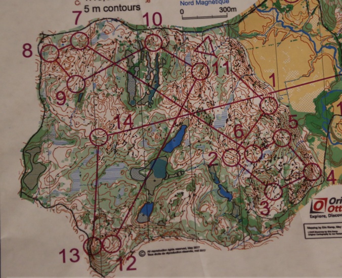
The very nice course that Jeff planned out for us
I was training with former junior national team members Alex and Robbie, and had a really good session with them. Intending to have a super easy run, my plan changed completely when both Robbie and Alex caught me by pretty much the first control egging me on to stay with them for the rest of the course (I can recall having a hard time keeping up). one of us finished the entire thing but rather ended 14 ending after an hour and a half.


The terrain was quite rocky and technical, reminded me of a weird mix of Scandinavian details and Slovenian karst terrain, as it had navigational aspects of both.


The distinct features and 5m contours made it fairly straightforward to orienteer between each leg. The most critical aspects of the run were picking the best macro route-choice and then keeping full contact with the map to maintain a perfect direction.


The final map worth noting was the March Highlands map which was again completely different from all of the other maps that I ran on. This one resembled typical Scandinavian mainland terrain with positive contour features inhabited by boulders and knolls, separated with occasional marshes or green.


The only downside was that bike trails cut across every hill, making the navigation alot simpler than if they were never there.
The March Highlands training, ending a mere 2 hours before my flight to Europe concluded the fruitful training week that I have spent in Ottawa. I had a great time and ran on a plethora of different styles of terrain that one does not often find so close to each other. (Usually the terrain is all similar around an area).
So if you are ever passing by Ottawa and want to get out on a high quality orienteering map, then there is not a shortage so don’t hesitate to contact the local club and get in touch with someone to see some unique terrains!
