Less than an hour after I had landed in Ottawa, I was already running my first training of the week at Algonquin College. A sprint map on the way to Jeff’s house, which seemed average but actually managed to catch me off guard on a leg. I did my classic warm up for training, (jogging to the start, some strides, leg swings etc….) before I came to the start and composed myself visualizing a race start.


The first leg; easy. Second leg; easy. Third leg; I failed to notice that part of the building was in fact building (thought that it was canopy) and got trapped, having to run around the left then, taking the slower route.


Next the course transitioned into a technical garden section where one had to have a solid plan to each control so that they wouldn’t get stuck in any of the pathways, or had to stop to read the map to see what is coming next.
This joy was shortly quelled by the long leg, which was well… a run.


Finally I looped through the assortment of buildings with a couple parkade walls, just trying to maintain a good flow through the section. At this point I was beginning to feel tired and winded, just trying to hold about a 5:00 min/km pace until the finishing kick. I ran it fairly cleanly and sprinted into the finish, concluding my first training in Ottawa.
Saturday was a gem training-wise, getting on Ottawa’s best forest map with Eric Kemp for 2 training sessions. The morning had a grim appearance and we had some clouds that rained on us some amount, having us wait to see if they would pass by. They must have gotten bored in our area because when we left at 11am then we could see the sun with only remnants of the clouds. As we were getting ready to run, some of the clouds above Gatneu park threatened to rain helping us hurry along.
We started together at a very fast pace before getting into the forest and cooling off a bit on the uphills. The terrain was quite fast navigation wise, yet slower running wise. To elaborate most of the map was white forest with rocky ground, yet it had thin saplings growing less than 2 meters apart between all of the trees. With the leaves down, this created an environment where you could read ahead making good plans with the distinct hills, and look up through the forest in order to find them.
I never got my hands on the pdf of the course so all I can show is a picture of an older version of the map.


My running speed was mostly limited by the rocky ground and then the low lying branches and saplings, which I had to weave through, taking time and focus off of map reading.
It was an amazing run even though I was a bit winded by the end of it. We then finished and drove over to the second training map.
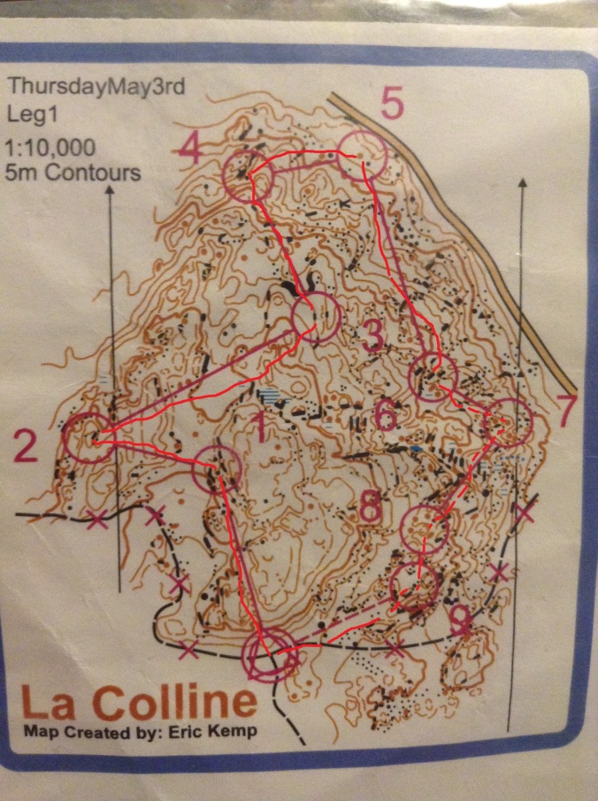
The second course
With 5m contours it was easy to read every hill meaning the critical thing to focus on was your bearing. The style that I used relied mainly on paying attention to the underlying contours and ignoring the little rocks knolls and cliffs. From 3 to 4 I implemented this, focusing on just the shape of the terrain in order to get into the control circle before I would micro to the flag.
")
")
The leg to 6 might have been my only mistake, where I ran up the hill and straight along the line the whole way. It might have been faster to run parallel to the contours along a little ramp before going up. The last few controls were the most technical, where I even hesitated a bit when I was inside of the control circle going to 7. But overall it was amazing terrain, clocking an additional 80m of climb over the 2km course!


